

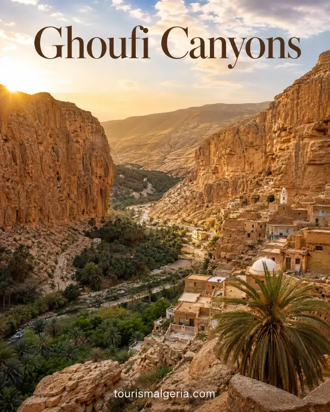
Ghoufi Canyons in Algeria
The Ghoufi Canyons in Algeria are a dramatic system of gorges in the Aurès Mountains, where the Oued Labiod cuts through layered rock between high plateaus and Saharan landscapes. The site combines spectacular geology, palm-filled oasis floors, traditional Chaoui villages, terraced agriculture and semi-troglodytic dwellings.
Where the Ghoufi Canyons Are Located
Ghoufi lies in the southwest of Batna Province, close to the municipality of Ghassira and the district of T’kout. Algeria’s Batna Tourism Directorate identifies the balconies as a major Aurès attraction and places them around one hundred kilometres from Batna, near the transition toward the Biskra region.
Official Batna Tourism Directorate – Ghoufi Balconies
Ghoufi Canyons in Algeria: How to Get There and Practical Visitor Information
Practical guide to visiting the Ghoufi Canyons, also known as the Balconies of Ghoufi, in the Aurès Mountains of Algeria, including location, access from Constantine, Batna and Biskra, opening conditions, hiking, parking, admission and important safety information.
Where Are the Ghoufi Canyons?
When Can You Visit?
| Period | Access |
|---|---|
| Monday-Sunday | No formal official opening hours. Outdoor viewpoints are normally accessible during daylight. |
| Morning | Recommended, especially during warmer months. |
| Afternoon | Suitable for viewpoints and photography, but allow enough daylight if descending into the canyon. |
| After sunset | Not recommended for canyon hiking because paths are steep, rocky and largely unlit. |
| Heavy rain / storms | Avoid canyon descent because trails can become slippery and water levels in the gorge can change. |
Entrance, Parking and Visit Duration
Why Ghoufi Is Special
How to Get to Ghoufi Canyons
Constantine to Ghoufi
Batna to Ghoufi
Biskra to Ghoufi
Bus, Taxi and Car
Descending Into the Canyon
Important Precautions
Season and Weather
Practical Equipment
Combine Ghoufi With Other Aurès Sites
Useful Internet Links
Nouvelle Cité Administrative, La Verdure, Batna, Algeria
Telephone: +213 33 81 29 56
Email: dta.batna@mta.gov.dz
An Official Tourist Site in Batna Province
The official Batna tourism authority classifies Ghoufi as a tourist expansion and development site within Ghassira municipality. Its published information emphasizes panoramic views over orchards beside the White Valley, cliffside settlements and the unusual meeting of mountainous terrain with a semi-desert climate.
Ghoufi in the Aurès Mountains
The wider Aurès massif forms one of northeastern Algeria’s most distinctive mountain regions. UNESCO’s 2025 tentative-list documentation describes steep slopes, summits rising above two thousand metres, deep valleys and a remarkable ecological transition in which northern mountain environments gradually give way to southern steppe and oasis landscapes.
The Oued Labiod Through the Canyon
The canyon is closely associated with the Oued Labiod, meaning White River, also rendered locally as Ighzer Amellal. Over immense geological timescales, flowing water cut into the sedimentary plateau, producing the deep gorge, layered cliffs and winding valley that now define the Ghoufi landscape.
How the Canyon Was Formed
UNESCO’s description explains that the Ghoufi canyon resulted from erosion of the sedimentary plateau by the waters of Oued Labiod over millions of years. The exposed layers, steep walls and sinuous valley create a landscape where geological processes remain immediately visible to travellers standing along the canyon rim.
Ghoufi on Algeria’s UNESCO Tentative List
In April 2025, Algeria submitted the oasis systems of the Ghoufi and Oued Labiod gorges to UNESCO’s World Heritage Tentative List. The proposal is classified as a mixed cultural and natural property under criteria relating to cultural traditions, human settlement and exceptional natural beauty.
UNESCO – Oasis Systems of the Ghoufi and Oued Labiod Gorges
Ghoufi Is Not Yet a World Heritage Site
Ghoufi is therefore not yet a UNESCO World Heritage Site. It is currently on Algeria’s Tentative List, which means the country may consider it for a future nomination. This distinction matters because some travel descriptions incorrectly present the canyon as already inscribed on the World Heritage List.
A Much Larger Proposed Cultural Landscape
The proposed UNESCO property covers a much wider landscape than the famous roadside viewpoints. It includes oasis systems, villages, mountain slopes, agricultural terraces, traditional irrigation, archaeological remains and settlements extending through parts of Batna and Biskra provinces, showing that Ghoufi belongs to a broader cultural landscape.
Where Mountains Meet the Sahara
One remarkable feature of this region is the rapid transition between northern mountains and the Sahara. UNESCO notes that cedar environments and palm groves can occur only around thirty kilometres apart, illustrating how elevation and relief create striking climatic, agricultural and botanical contrasts within a relatively short distance.
The Famous Ghoufi Balconies
The expression “Ghoufi Balconies” refers to the viewpoints and cliffside formations overlooking the gorge. From these elevated positions, visitors can see the river corridor, palm groves, abandoned houses and terraced slopes far below, while horizontal bands in the rock emphasize the depth and scale of the canyon.
Villages Built Into the Canyon
The balconies are memorable because human settlement appears integrated directly into the cliffs. Instead of standing apart from the landscape, old houses, walls and paths use natural ledges and rock formations, creating the impression that entire villages were shaped together with the canyon rather than simply built beside it.
Traditional Dechras on the Slopes
Traditional settlements in the gorge include terraced villages known locally as dechras. UNESCO highlights this settlement pattern as an adaptation to steep terrain, with communities arranging houses, paths and cultivated plots according to the natural contours of the slopes while remaining close to scarce water and fertile ground.
Semi-Troglodytic Houses
Some Ghoufi dwellings are described as semi-troglodytic because builders incorporated natural cavities and rock shelters into constructed homes. Stone and earth walls extended these protected spaces, reducing exposure to temperature extremes and allowing families to use the geology itself as part of the architecture rather than merely as a foundation.
Chaoui Heritage in Ghoufi
The cultural landscape is closely associated with the Chaoui, an Amazigh population of the Aurès. UNESCO’s tentative-list documentation emphasizes the survival of Chaoui language, customs, rural traditions and forms of settlement, making Ghoufi important not only for scenery but also for understanding a distinctive North African mountain society.
Architecture Using Local Materials
Traditional architecture relied heavily on materials available in the surrounding landscape. Local limestone, earth and timber were combined according to practical knowledge developed over generations. The resulting colours closely match the canyon walls, helping explain why abandoned houses can appear almost indistinguishable from the rock when viewed from afar.
Traditional Irrigation in the Gorge
Water management made permanent settlement possible in this demanding environment. UNESCO describes traditional seguias, or small irrigation channels, together with dry-stone works used to capture and redistribute seasonal water. These systems directed limited supplies toward orchards, palm groves and cultivated terraces where agriculture could survive despite an arid climate.
Palm Groves on the Canyon Floor
Date palms are among the most striking plants on the canyon floor. Their green crowns form a ribbon through the brown and ochre gorge, signalling water below. In the oasis system, palms also create shade that helps protect fruit trees and lower crops from intense sun and evaporation.
An Oasis with Several Agricultural Layers
The oasis is more diverse than a simple date plantation. UNESCO describes layered agricultural systems in which palms provide a protective upper canopy, fruit trees occupy a second level and vegetables grow below. This vertical organization creates a moderated microclimate and makes efficient use of limited fertile land.
Traditional Villages Around Ghoufi
The abandoned and inhabited villages around the Aurès help explain Ghoufi as a cultural landscape rather than an isolated geological attraction. Dechras, collective structures, terraces and paths record generations of adaptation to steep mountains, while the surrounding valleys preserve continuing agricultural practices and elements of traditional Chaoui social organization.
Ghassira and the Ghoufi Site
Ghassira is the municipality most directly associated with the Ghoufi tourist site. The Batna Tourism Directorate places the officially designated Ghoufi expansion zone there, within the district of T’kout. Travellers searching maps should therefore use Ghassira, Ghoufi and T’kout together rather than expecting a separate modern city called Ghoufi.
Arris in the Heart of the Aurès
Arris is another important Aurès centre that fits naturally into a Ghoufi itinerary. UNESCO describes it as a major settlement surrounded by terraced villages and irrigated gardens. Travellers coming from Batna commonly pass through or near this mountainous part of the Aurès before continuing toward deeper southern valleys.
T’kout and the Ghoufi Region
T’kout is closely linked administratively and geographically with the Ghoufi area. Roads through this part of the Aurès reveal changing mountain scenery, villages and valleys, while the town can serve as a useful reference point when arranging local transport or discussing the canyon route with guides and accommodation providers.
Menaa and Its Traditional Landscape
Menaa lies in another celebrated Aurès valley and is included in UNESCO’s proposed mixed landscape. Its dense traditional settlement occupies a dramatic position where valleys meet, illustrating how local builders adapted architecture to mountain topography. Combining Menaa with Ghoufi provides a broader understanding of traditional Aurès villages and irrigated agriculture.
El Kantara and the Gate to the Desert
El Kantara, farther toward Biskra, represents another remarkable transition between mountains and desert. UNESCO describes its gorge, palm grove and historic settlement as one of the important landscapes in the proposed property. Travellers linking Ghoufi with Biskra can therefore experience several contrasting examples of oasis life within one journey.
How to Visit the Ghoufi Canyons
A Ghoufi visit works best as a road excursion combined with walking at selected viewpoints. The attraction is spread across a large landscape rather than contained within a fenced monument. Visitors should allow time for stops, photography, short descents and conversations instead of planning only a quick roadside photograph.
Travelling from Batna
The Batna Tourism Directorate states that Ghoufi is about one hundred kilometres from Batna. The journey takes travellers south through the Aurès, so travel time depends on road conditions, stops and route choice. Batna remains a practical base because it offers transport and accommodation infrastructure.
Batna Tourism Directorate – Accommodation Information
Combining Ghoufi with Biskra
Biskra can also be incorporated into a Ghoufi itinerary because the canyon lies near the mountainous transition toward the Ziban region. Official tourism information notes that the Ahmar Khaddou massif separates this Aurès landscape from the Biskra desert, creating a particularly attractive route between highlands and Saharan oasis country.
The Road Is Part of the Experience
The road itself is part of the experience. Approaching Ghoufi reveals dry slopes, mountain folds, cultivated pockets and sudden canyon viewpoints. Drivers should concentrate carefully because scenic roads can include bends, changing surfaces and roadside stops, while passengers can appreciate the rapid shift between mountain and semi-desert conditions.
Descending Into the Canyon
Descending toward the canyon floor offers a different perspective from the balconies, but paths can be steep, uneven and exposed. Visitors should not treat old village routes like prepared urban walkways. Heat, recent rain and maintenance can change accessibility, so a descent should be judged realistically that day.
Using a Local Guide
A knowledgeable local guide can add substantial value, especially for travellers interested in abandoned settlements, Chaoui culture or longer walks. A guide can distinguish paths from unstable areas, explain traditional irrigation and architecture, and help visitors understand features that are easy to overlook when viewing the canyon only from above.
The Best Seasons for Ghoufi
Spring and autumn are often comfortable periods for exploring the Aurès on foot because summer heat can intensify in lower valleys while winter brings colder mountain conditions. Weather varies sharply with altitude, so visitors should check a current local forecast shortly before travelling instead of relying only on seasonal expectations.
Strong Temperature Contrasts
Temperature contrasts are an important feature of the proposed UNESCO landscape. The tentative-list documentation emphasizes strong daily and seasonal variations created by the transition from mountains to arid southern areas. Travellers should carry layers, sun protection and sufficient water even when conditions initially appear comfortable at higher altitude.
Footwear and Water
Good walking shoes are preferable to sandals when leaving the main viewpoints. Loose stone, dust, worn steps and steep gradients can make paths slippery. Water is essential, particularly during warm weather, and travellers should avoid a long descent late in the day without enough time for the return climb.
Photographing the Ghoufi Canyon
Ghoufi is exceptionally rewarding for photography because every elevation produces a different composition. Wide views capture the layered gorge, while closer perspectives reveal palms, old walls, terraces and rock shelters. Morning and late-afternoon light usually emphasizes the canyon’s colours and textures more effectively than harsh overhead midday sun.
Combining Ghoufi with Timgad
Timgad can be combined with Ghoufi when travelling through Batna Province. The Roman city is already inscribed on UNESCO’s World Heritage List and provides a striking contrast with the Aurès cultural landscape: formal Roman urban planning at Timgad versus vernacular mountain and oasis settlement around the Ghoufi gorge.
Visiting Roman Lambaesis Near Batna
The wider Batna region also contains Lambaesis at modern Tazoult, another major Roman archaeological site. The Batna Tourism Directorate places it about ten kilometres east of Batna. Combining Roman remains with Ghoufi demonstrates how the province contains very different historical layers within relatively accessible road itineraries.
Official Batna Tourism Directorate – Lambaesis
Exploring the Wider Natural Landscape
Nature-focused travellers can also explore Belezma National Park in the broader Batna region. Ghoufi itself highlights the southern Aurès transition toward aridity, while northern mountain areas contain different forests and ecological conditions. Together they help explain the exceptional environmental diversity emphasized in Algeria’s UNESCO tentative-list proposal.
Protecting the Ghoufi Cultural Landscape
Protecting Ghoufi requires preserving both nature and human heritage. UNESCO’s assessment notes pressures including rural depopulation, loss of traditional skills and changes affecting water systems. Visitors can help by staying on established paths, avoiding damage to abandoned structures, taking waste away and respecting cultivated land and local communities.
Author and Update
This guide was written and updated on 28 August 2026 by Nabil Frik for TourismeAlgerie.com. Ghoufi is currently on Algeria’s UNESCO Tentative List, not the final World Heritage List. Travellers should verify road, weather and access conditions with the Batna Tourism Directorate or local tourism professionals before departure.
Official Batna Tourism Directorate