

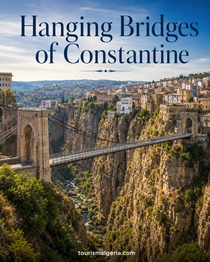
Hanging Bridges of Constantine in Algeria
The Hanging Bridges of Constantine are a network of dramatic crossings spanning the deep Rhumel gorge in northeastern Algeria. They include true suspension bridges, monumental masonry arches and a modern cable-stayed viaduct, together forming the architectural identity that gives Constantine its celebrated reputation as Algeria’s City of Bridges.
Constantine and Its Extraordinary Bridge Landscape
Constantine’s bridges are inseparable from the city’s geography. The historic centre occupies a rocky plateau broken by steep cliffs and the Rhumel gorge, forcing generations of engineers to connect neighbourhoods across difficult terrain while creating viewpoints that today rank among the city’s most memorable attractions.
Hanging Bridges of Constantine in Algeria: How to Get There and Practical Information
Practical guide to Constantine’s famous suspension bridges, including addresses, opening times, admission, access from the city centre, Ahmed Bey Palace and Mohamed Boudiaf Airport, historical information, viewpoints and practical advice.
Sidi M’Cid Bridge
Mellah Slimane Bridge
Sidi M’Cid Bridge Hours
| Day | Access |
|---|---|
| Monday | Open 24 hours |
| Tuesday | Open 24 hours |
| Wednesday | Open 24 hours |
| Thursday | Open 24 hours |
| Friday | Open 24 hours |
| Saturday | Open 24 hours |
| Sunday | Open 24 hours |
Mellah Slimane Bridge Hours
| Facility | Access |
|---|---|
| Footbridge | Free pedestrian access 24 hours a day. |
| Stairway | Pedestrian access; long staircase between levels. |
| Historic elevator | Operating availability can vary; current visitor guides commonly list a very small fare of approximately 5 DZD. |
Sidi M’Cid Bridge
Mellah Slimane Footbridge
How to Get to the Hanging Bridges
Walking to Sidi M’Cid
Combine the Palace and Bridges
Mellah Slimane Is the Convenient Bridge
Mohamed Boudiaf Airport
Where to Take Photos
Practical Precautions
Continue the Constantine Bridge Tour
Useful Internet Links
Rue Shehani Bashir, Prince Abdelkader district, Kantara, Constantine
Telephone: +213 31 85 97 92
Email: dta.constantine@mta.gov.dz
The Rhumel Gorge Beneath the City
The Rhumel River cuts through limestone beneath the old city, producing a narrow canyon with sheer walls and striking changes in elevation. From several bridges, visitors can look toward roads, tunnels, vegetation and buildings stacked above the gorge, revealing why Constantine developed such an extraordinary system of crossings.
Hanging Bridges and Other Types of Crossings
Not every famous Constantine crossing is technically a hanging bridge. Sidi M’Cid and Mellah Slimane are suspended structures, Sidi Rached is a monumental masonry viaduct, El Kantara is an historic arch crossing, while Salah Bey uses modern cable-stayed engineering to span another section of the Rhumel valley.
Sidi M’Cid Suspension Bridge
Sidi M’Cid is Constantine’s most iconic suspension bridge and the image most often associated with the city. Its narrow deck, stone towers and sweeping cables cross a spectacular gap above the Rhumel, giving pedestrians and drivers an immediate impression of the height and dramatic geology beneath the historic plateau.
Height and Length of Sidi M’Cid
Constantine’s Tourism Directorate states that Sidi M’Cid was inaugurated on 19 April 1912. The official description gives a length of 160 metres and places the deck around 175 metres above the Rhumel waters, dimensions that explain why the crossing remains exceptionally impressive more than a century later.
Official Constantine Tourism – Sidi M’Cid Bridge
Ferdinand Arnodin and the Engineering
The bridge is associated with engineer Ferdinand Arnodin, a specialist in suspended and cable-supported structures. Its design combines the visual lightness of suspension cables with strong anchorages and towers, demonstrating how early twentieth-century engineering adapted ambitious bridge technology to Constantine’s unusually steep and constrained urban landscape.
A Bridge Created for Everyday Movement
Sidi M’Cid was created for practical movement rather than sightseeing alone. By linking opposite sides of the gorge, it improved access between important urban areas and reduced difficult detours. Its success shows how Constantine’s celebrated bridges emerged first as solutions to everyday transport problems created by the city’s topography.
Walking Across Sidi M’Cid
Walking across Sidi M’Cid is one of Constantine’s essential experiences. The bridge provides open views into the gorge and toward surrounding districts, but the height can feel intense for visitors uncomfortable with exposure. Pedestrians should remain within designated areas and stay attentive to any nearby vehicle traffic.
The Best Views of Sidi M’Cid
Excellent views of Sidi M’Cid can be found from nearby elevated areas around the Monument to the Dead and routes following the gorge. Photographing from more than one side is worthwhile because the bridge’s cables, towers and relationship with the cliffs change dramatically according to angle and light.
Mellah Slimane Suspension Footbridge
Mellah Slimane is Constantine’s other celebrated suspension crossing and is primarily a pedestrian footbridge. Formerly known as the Perrégaux footbridge, it links the railway-station side with the historic centre, providing a lighter and more intimate experience than Sidi M’Cid while still hanging high above the Rhumel gorge.
Preserving Mellah Slimane
Constantine’s tourism authority has treated Mellah Slimane as an important historic and tourist landmark, including works to improve stairs, cleanliness, lighting and surrounding spaces. This attention reflects the bridge’s continuing importance as both an everyday pedestrian connection and one of the defining components of the city’s suspended-bridge heritage.
Constantine Tourism – Mellah Slimane restoration information
The Famous Elevator Bridge
The footbridge is also widely known locally as the elevator bridge because its connection with the city centre includes stairs and an elevator system. This unusual vertical access illustrates Constantine’s terrain perfectly: crossing the gorge often requires dealing not only with horizontal distance but also with major differences in elevation.
Crossing Mellah Slimane on Foot
Crossing Mellah Slimane gives pedestrians time to appreciate the canyon without the same relationship to road traffic found on some other bridges. The narrow suspended deck can transmit slight movement under footsteps, while open views toward the rock walls and city create one of Constantine’s most distinctive walking experiences.
Sidi Rached Bridge
Sidi Rached Bridge offers a completely different architectural language. Instead of hanging from cables, the enormous viaduct uses a sequence of masonry arches to cross the valley. Its monumental mass and long profile make it one of Constantine’s most recognizable landmarks and a dramatic contrast with the lighter suspension bridges.
Dimensions of Sidi Rached Bridge
The official Constantine Tourism Directorate states that Sidi Rached opened to traffic in 1912. It measures 447 metres long and 10.5 metres wide, with twenty-seven arches. The largest arch spans about 70 metres, giving the structure an imposing scale among early twentieth-century masonry bridges.
Official Constantine Tourism – Sidi Rached Bridge
Stone Arches Above the Valley
Seen from lower viewpoints, Sidi Rached appears firmly anchored into the landscape rather than floating above it. Repeated stone arches create a powerful rhythm across the valley, demonstrating a very different engineering response to Constantine’s geography from the steel cables of Sidi M’Cid and the modern stays of Salah Bey.
El Kantara Bridge and Centuries of History
El Kantara occupies one of Constantine’s oldest bridge locations. According to the official tourism authority, Salah Bey built a bridge there in 1792 on the remains of an earlier Roman crossing. The site therefore represents centuries of continuity in the need to connect the two sides of the Rhumel gorge.
Reconstruction of El Kantara
The El Kantara crossing was later reconstructed during the French colonial period. Constantine’s Tourism Directorate states that rebuilding occurred around 1860 and the bridge reopened to traffic in 1863. Its layered history makes it particularly valuable for travellers interested in how ancient, Ottoman and engineering reused the same strategic location.
Official Constantine Tourism – El Kantara Bridge
The Bridge of the Falls
The Bridge of the Falls stands lower in the Rhumel landscape and offers another relationship with water. Official Constantine tourism information states that it was built in 1928 near the route toward the swimming area, where the river passes beneath the bridge and forms visible cascades through the rocky gorge.
Constantine Tourism – Bridge of the Falls
Constantine’s Devil’s Bridge
The small crossing known as the Devil’s Bridge is less monumental than Constantine’s celebrated suspension and masonry structures, yet it contributes to the city’s bridge story. Its position deep within the gorge gives visitors a closer sense of the Rhumel’s force and the difficult landscape that shaped urban development.
Salah Bey Bridge and Modern Constantine
Salah Bey Bridge represents the modern phase of Constantine’s bridge-building tradition. Completed in the twenty-first century, the cable-stayed viaduct uses tall pylons and inclined stays rather than classical suspension cables. Its clean geometric form introduces contemporary engineering into a skyline already defined by historic crossings above the Rhumel.
A Modern Cable-Stayed Landmark
Designers Dissing+Weitling and COWI describe the Salah Bey Bridge as Constantine’s first cable-stayed bridge. Their project information gives the principal structure a length of 750 metres and pylons approximately 130 metres high, connecting the ONU area with the Mansourah plateau across difficult geological conditions.
Dissing+Weitling – Salah Bey Bridge project
Opening a New Chapter in the City
The larger Salah Bey crossing, including associated sections, is often described as extending beyond one kilometre. Construction began during the early 2010s and the bridge entered service in 2014. Its opening created a contemporary traffic connection while adding a new landmark to Constantine’s long-established identity as the City of Bridges.
Engineering for Difficult Ground Conditions
The Salah Bey project was designed for demanding geotechnical and seismic conditions. Engineering information emphasizes foundations, structural stability and resistance appropriate to the region. This technical dimension makes the bridge interesting beyond its appearance, showing how modern designers must respond to the same difficult terrain that challenged earlier bridge builders.
An Open-Air Museum of Bridge Engineering
Together, Constantine’s bridges function like an open-air museum of engineering. Visitors can compare Ottoman and nineteenth-century crossings, early twentieth-century suspension technology, large masonry arches and twenty-first-century cable-stayed construction, all within one compact urban landscape shaped by the same river, cliffs and persistent need to connect separated districts.
Follow the Official Bridge Walking Route
The Constantine Tourism Directorate proposes a cultural walking itinerary linking several bridges with major monuments. Its route includes Sidi Rached, Mellah Slimane, the railway station, El Kantara, older crossings, Sidi M’Cid, the Monument to the Dead, Ahmed Bey Palace, the old city and Constantine’s historic theatre.
Official Constantine cultural and archaeological routes
Combine the Bridges with Ahmed Bey Palace
Ahmed Bey Palace is an excellent addition to a bridge itinerary because it introduces Constantine’s Ottoman political history. The palace stands within the historic centre and preserves architecture associated with the final Bey of Constantine, allowing travellers to combine nineteenth-century interiors with the dramatic engineering landscape outside.
Official Constantine Tourism – Ahmed Bey Palace
Visit the National Cirta Museum
The National Cirta Museum provides an even older historical layer. Its archaeological collections relate to Numidian, Punic and Roman periods associated with ancient Cirta. Visiting the museum before or after the bridges helps explain why this strategic rocky site was important long before the modern city acquired its famous crossings.
Walk Through Constantine’s Old City
Walking through Constantine’s old city makes the bridges feel part of everyday urban life rather than isolated attractions. Narrow streets, markets, mosques, public buildings and residential areas suddenly open toward the gorge, creating dramatic transitions between dense city fabric and the enormous vertical space surrounding the Rhumel below.
Photographing the Hanging Bridges of Constantine
Photographers should treat Constantine as a network of viewpoints rather than searching for one perfect location. Sidi M’Cid is impressive in profile, Mellah Slimane rewards closer pedestrian compositions, Sidi Rached benefits from lower angles, while Salah Bey can be framed against modern districts and the broader valley landscape.
Morning Views Across the Gorge
Morning light can reveal texture in the limestone cliffs while keeping parts of the gorge in deep shadow. Conditions vary by season and orientation, so moving between viewpoints is more effective than remaining in one place. Early hours may also provide calmer pedestrian conditions around the most popular historic crossings.
Sunset and Evening Photography
Late afternoon and sunset can give the bridges a warmer appearance as stone towers, arches and façades catch low light while the gorge darkens. Evening illumination can add another visual dimension, particularly around modern infrastructure, although photographers should remain careful near traffic, railings and exposed viewpoints after daylight fades.
Choosing a Comfortable Season
Spring and autumn are generally comfortable periods for exploring Constantine on foot because temperatures are often milder than in midsummer. Winter can bring cold, rain and wind on exposed bridges. Visitors planning a long bridge route should check current local weather conditions and adapt footwear and clothing accordingly.
Staying Safe Above the Rhumel
Safety is important because several viewpoints and crossings stand extremely high above the Rhumel. Visitors should stay behind barriers, avoid climbing railings, supervise children closely and respect temporary closures. Wet stone, worn stairs and steep approaches can become slippery after rain, especially on older routes around the gorge.
Pedestrians and Road Traffic
Some Constantine bridges carry road traffic while others are focused on pedestrians. Sidi M’Cid requires awareness of vehicles and narrow space, whereas Mellah Slimane offers a more pedestrian-oriented crossing. Visitors should follow current signs because maintenance, restoration or traffic management can temporarily change how a particular bridge is accessed.
Accessibility Around the Bridges
Accessibility varies considerably across the bridge network. Mellah Slimane’s historical elevator connection can assist with major changes in elevation, but stairs, steep streets and uneven surfaces remain common throughout the old city. Travellers with reduced mobility should verify current elevator operation and route conditions before planning a long walking circuit.
Exploring Constantine with a Local Guide
A local guide can add value by explaining historic bridge names, neighbourhood connections, engineering details and less obvious viewpoints. Independent visitors can instead follow the official Constantine tourism itinerary, which already organizes major bridges and monuments into a coherent route through the city centre and surrounding sections of the gorge.
Why Constantine’s Hanging Bridges Are Worth Visiting
The Hanging Bridges of Constantine are worth visiting because nowhere else in Algeria combines urban history, dramatic geology and successive generations of bridge engineering so densely. Sidi M’Cid delivers the iconic suspended view, while Mellah Slimane, Sidi Rached, El Kantara and Salah Bey reveal different chapters of the city’s development.
Author and Update
This guide was written and updated on 29 August 2026 by Nabil Frik for TourismeAlgerie.com. Bridge access, elevators, traffic arrangements, restoration works and viewpoint conditions can change, so travellers should verify current information with Constantine’s Tourism and Handicrafts Directorate before planning a detailed walking or photography itinerary.
Constantine Tourism and Handicrafts Directorate
Algeria trip planer 3 days, 5 days, 7 days
Hotels Comparator in Algeria
Algiers-Kasbah english speaking guide
Algeria Ferries
Algerie Car Rental
Sahara Desert Hotels in Algeria
Algeria Visa Application
Casbah of Algiers
Algiers Church of Notre-Dame d’Afrique
Makam El Chahid
Algeria Flights
Algeria Tour Operators
Algeria Airports Timetable
Algeria Tourism Video
Algeria Tourism Board
Algeria Train Services