

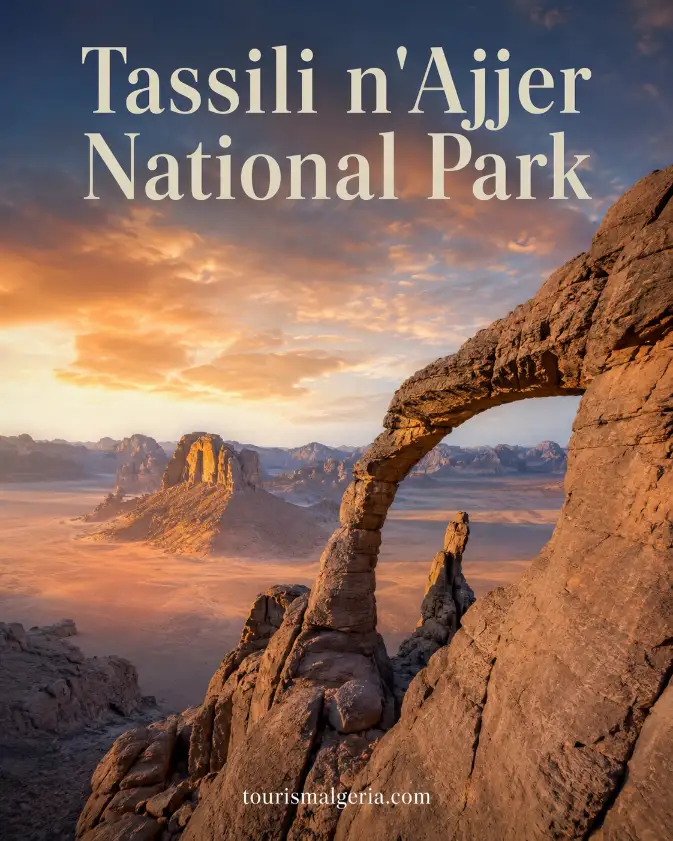
Tassili n’Ajjer National Park in Algeria
Tassili n’Ajjer National Park is a vast protected desert landscape in southeastern Algeria, celebrated for prehistoric rock art, eroded sandstone formations, rare Saharan ecosystems, and Tuareg cultural heritage. The UNESCO-listed area combines archaeology and nature on a scale that makes it one of Africa’s most remarkable protected regions.
A Cultural and Natural Desert Landscape
Unlike a conventional national park focused mainly on wildlife, Tassili n’Ajjer protects an entire cultural and natural landscape. Ancient paintings, burial sites, rock shelters, canyons, gueltas, dunes, and living communities coexist across an immense territory where geology and human history have been intertwined for thousands of years.
Tassili n’Ajjer National / Cultural Park – Practical Visitor Information
How to reach Tassili n’Ajjer through Djanet, address and official contacts, visiting and access arrangements, permits, compulsory guides, rock art, desert expeditions, camping, climate, photography and UNESCO heritage information.
Where Tassili n’Ajjer Is Located
Tassili n’Ajjer lies in Algeria’s far southeast, close to the borders with Libya, Niger, and Mali. The World Heritage property covers about 72,000 square kilometres, extending across a remote Saharan region where distances are large and organized travel is essential for reaching the principal archaeological and scenic areas.
UNESCO World Heritage Recognition
UNESCO inscribed Tassili n’Ajjer on the World Heritage List in 1982 as a mixed cultural and natural property. It remains Algeria’s only mixed World Heritage site, recognized simultaneously for extraordinary prehistoric art, exceptional geological scenery, archaeological testimony, and natural values preserved within its immense desert environment.
The Sandstone Plateau
The landscape is dominated by an elevated sandstone plateau cut by ravines, canyons, valleys, and isolated massifs. UNESCO describes its eroded formations as forests of rock, an expression that captures the strange concentration of pillars, arches, towers, walls, and sculpted shapes created by water, wind, and geological time.
Forests of Rock
Many parts of Tassili resemble a natural stone city rather than an open desert. Narrow passages run between sandstone walls, balanced formations rise above sandy floors, and huge arches frame the sky. Light changes these forms constantly, producing dramatic scenery around sunrise, sunset, and cooler hours of the day.
A High Saharan Plateau
The plateau generally rises well above the surrounding Sahara, with important sectors lying around 1,500 to 1,800 metres above sea level. This elevation contributes to cooler nights, distinctive ecological conditions, and viewpoints where visitors can look across enormous expanses of rock, dunes, wadis, and distant desert horizons.
One of the World’s Great Rock-Art Regions
Tassili n’Ajjer is internationally famous for one of the world’s greatest concentrations of prehistoric rock art. UNESCO records more than 15,000 drawings and engravings, creating an extraordinary visual archive of human life, animals, beliefs, movement, and environmental change across many different periods of Saharan prehistory.
Images of a Greener Sahara
The rock art is valuable not simply because it is old, but because it documents major changes in the Sahara. Images of cattle, hunters, human groups, wild animals, and water-dependent species reveal that landscapes now extremely dry once supported environments and ways of life very different from those visible today.
Animals from Ancient Climates
Among the most striking subjects are animals associated with wetter conditions, including species no longer found in this part of the Sahara. Their presence in ancient art helps researchers understand climatic change, animal migrations, and the gradual transformation of northern Africa from greener landscapes toward the hyper-arid desert known today.
Different Periods of Rock Art
Tassili’s paintings and engravings belong to several artistic and cultural phases rather than one single prehistoric moment. Differences in style, subject, scale, and technique allow archaeologists to study changing societies over long periods, from early hunter communities through pastoral cultures and later phases connected with horses and camels.
Archaeological Evidence Beyond the Paintings
The importance of the rock art extends beyond individual images. Shelters, habitation traces, burial mounds, stone tools, pottery, and other archaeological remains show that generations of people repeatedly used this landscape. Together, these materials create a much broader record of adaptation to changing Saharan environments and resources.
Sefar and Remote Rock-Art Landscapes
Sefar is among the best-known rock-art areas associated with the Tassili plateau. Reaching remote archaeological sectors can require demanding trekking across rocky terrain, making the journey itself part of the experience. Visitors encounter paintings and shelters within a landscape whose isolation helps explain both their survival and their vulnerability.
Jabbaren and Prehistoric Shelters
Jabbaren is another celebrated rock-art zone known for numerous paintings and archaeological remains. Like other remote Tassili sites, it should be experienced with qualified local guidance. The significance lies not merely in photographing famous images, but in understanding their position within shelters, routes, water sources, and wider prehistoric landscapes.
Djanet as the Main Gateway
Djanet is the principal gateway for travellers exploring Tassili n’Ajjer. This oasis town provides accommodation, guides, transport arrangements, supplies, and connections with the surrounding desert. Its location makes it the practical starting point for excursions toward rock-art sectors, dunes, canyons, mountain landscapes, and protected cultural sites.
Discovering Djanet Before the Desert
Djanet is more than a logistical base because it has its own distinctive cultural identity. Palm groves, traditional neighbourhoods, local markets, surrounding mountains, and Tuareg heritage give visitors an introduction to southeastern Algeria before they travel into more remote areas of the protected landscape.
Tuareg Knowledge and the Tassili
The wider Djanet region is closely associated with Tuareg communities whose knowledge of routes, water, weather, livestock, and desert geography remains invaluable. Travelling with local professionals therefore provides more than navigation: it introduces place names, oral traditions, environmental understanding, and cultural perspectives rooted in generations of Saharan experience.
The Imzad Tradition
Tuareg cultural heritage around Tassili also includes the imzad, a traditional single-string instrument whose practices and knowledge are recognized by UNESCO as intangible cultural heritage. The tradition demonstrates that the region’s importance is not limited to prehistoric remains; living music, language, craftsmanship, and social memory remain equally significant.
Sebeiba in Djanet
Djanet is also famous for Sebeiba, a ritual and ceremonial tradition recognized by UNESCO as intangible cultural heritage. The annual event involves music, dress, poetry, and ceremonial performance, illustrating how contemporary community traditions continue to give the Tassili region a cultural vitality extending far beyond its archaeological reputation.
From National Park to Cultural Park
The Tassili n’Ajjer landscape is officially managed today through Algeria’s cultural-park system. This approach reflects the inseparable relationship between archaeological sites, natural habitats, scenery, and local communities. Protection therefore concerns not only monuments or wildlife individually, but the functioning cultural landscape in which these elements coexist.
A UNESCO Biosphere Reserve
Tassili n’Ajjer also forms part of UNESCO’s World Network of Biosphere Reserves. The biosphere designation recognizes the region’s ecological importance alongside human use and conservation. It covers a much larger area than the World Heritage property and includes habitats ranging from high plateaus to wadis, gueltas, dunes, and pastoral landscapes.
Rare Plants in an Extreme Environment
Despite its severe climate, Tassili contains remarkable plant life adapted to altitude, drought, and isolated water sources. UNESCO identifies relict species including the Saharan cypress, wild olive, and myrtle. These survivors provide evidence of earlier climatic periods while adding exceptional biological value to an apparently barren desert landscape.
The Saharan Cypress
The Saharan cypress, Cupressus dupreziana, is one of Tassili’s most remarkable botanical treasures. Small surviving populations endure in remote mountain environments under extremely dry conditions. These ancient-looking trees symbolize the fragility of relict ecosystems and the importance of protecting water, soils, and vegetation from unnecessary disturbance.
Wildlife Across the Protected Landscape
Wildlife is equally adapted to difficult conditions. Recent UNESCO biosphere assessments emphasize the conservation importance of Tassili for Saharan fauna, including threatened species. Animals are naturally difficult to observe across such a vast territory, so travellers should regard wildlife sightings as fortunate encounters rather than guaranteed attractions.
Gueltas and Desert Water
Gueltas are natural pools or waterholes that form within rocky valleys and can persist after rainfall. In a hyper-arid environment, these small water bodies have exceptional ecological importance for plants, animals, pastoral communities, and travellers. Their fragility makes responsible behaviour around water sources particularly important.
The Iherir Valley
The Iherir Valley is one of the most important wetland landscapes associated with Tassili n’Ajjer. Its gueltas, vegetation, dramatic cliffs, and cultural heritage create a rare concentration of life within the desert. International wetland recognition underlines the ecological importance of conserving these water-dependent habitats and their surroundings.
Dunes Beside the Rock Massifs
Sand dunes add another visual dimension to the region, particularly around the broader landscapes accessible from Djanet. Their smooth surfaces contrast with dark and weathered sandstone towers. Wind constantly redraws dune crests and ripples, so familiar viewpoints can appear different from one visit, season, or even day to another.
Tadrart and the Wider Djanet Landscape
The Tadrart landscapes south of Djanet are especially celebrated for combinations of dunes, natural arches, rock towers, and changing colours. Although itineraries vary, many travellers include this desert region in a wider Tassili journey because it presents some of southeastern Algeria’s most spectacular geology and photographic scenery.
Sunrise in Tassili n’Ajjer
Sunrise in Tassili reveals the desert gradually. Rock formations first appear as silhouettes before warm light reaches cliffs, arches, and dune crests. Early hours are also valuable for walking because temperatures are generally cooler, making dawn excursions particularly rewarding for photographers, trekkers, and travellers sensitive to intense daytime heat.
Sunset Across the Sandstone
Sunset produces equally dramatic changes as sandstone surfaces become warmer and long shadows emphasize geological relief. Because darkness arrives quickly in desert environments, visitors watching sunset away from camp should remain with their guide, carry appropriate lighting, and avoid moving independently across unfamiliar rocky or sandy terrain afterward.
Stargazing in the Sahara
Night brings another dimension to Tassili n’Ajjer. Remote camps can offer exceptionally dark skies when weather and moonlight conditions cooperate. Stars appear above the silhouettes of sandstone formations, creating memorable evenings, but temperatures can fall sharply, so warm layers remain essential even after hot daytime conditions.
Choosing the Best Travel Season
The most comfortable periods for desert travel are generally the cooler months, when daytime exploration is easier than during peak summer heat. Temperature differences between day and night can be considerable. Travellers should prepare for sun, wind, cold evenings, and changing conditions rather than relying on one type of clothing.
Preparing for a Remote Expedition
A Tassili expedition requires more preparation than an ordinary city excursion. Water, suitable footwear, sun protection, layered clothing, personal medication, and dependable transport arrangements are essential. Remote travel may involve several days away from urban facilities, so expectations about accommodation, electricity, communications, and sanitation should remain realistic.
Travelling with an Official Guide
UNESCO notes that tourism within the World Heritage property is strictly controlled and visitors are accompanied by official guides. This requirement protects travellers as well as archaeological and natural heritage. Local guides know permitted routes, sensitive areas, water conditions, campsites, and the behaviour expected around rock-art shelters and protected landscapes.
Protecting the Rock Art
Rock art must never be touched, wetted, chalked, traced, or rubbed to improve photographs. Even small interventions can damage pigments and surfaces that survived for thousands of years. Visitors should also avoid leaning against painted shelters or moving archaeological objects, regardless of how insignificant those objects may initially appear.
Managing Waste Responsibly
Waste management is another important responsibility because remote desert environments provide few opportunities for cleanup. Travellers should remove all non-organic rubbish, minimize disposable packaging, protect scarce water sources, and avoid disturbing vegetation. Responsible operators can explain appropriate practices for camps, cooking, sanitation, and movement through sensitive areas.
Photography in Tassili n’Ajjer
Photography is one of Tassili’s great pleasures, but the best images often come from patience rather than approaching fragile surfaces. Wide compositions can place rock art within its shelter, while landscape photography benefits from early and late light. Permission should always be requested before photographing local residents closely.
Allow Enough Time for the Journey
Travellers should allow enough time for Tassili because distances and terrain make rushed itineraries impractical. A short stay can explore accessible landscapes around Djanet, while deeper archaeological zones require longer expeditions. Multi-day journeys provide a much stronger understanding of how geology, archaeology, ecology, and Tuareg knowledge connect.
Why Tassili n’Ajjer Is Exceptional
Tassili n’Ajjer is exceptional because few places combine prehistoric art and natural scenery on such a vast scale. The same journey can reveal ancient paintings, monumental arches, narrow canyons, dunes, rare plants, waterholes, and living Tuareg traditions, making the region one of Algeria’s most profound cultural landscapes.
Author and Update
This guide was written and updated on 29 August 2026 by Nabil Frik for TourismAlgeria.com. Travellers planning Tassili n’Ajjer should verify current access, guide requirements, transport arrangements, weather, and permitted routes before departure, because conditions within this remote and protected Saharan region can change.
Algeria trip planer 3 days, 5 days, 7 days
Hotels Comparator in Algeria
Algiers-Kasbah english speaking guide
Algeria Ferries
Algerie Car Rental
Sahara Desert Hotels in Algeria
Algeria Visa Application
Casbah of Algiers
Algiers Church of Notre-Dame d’Afrique
Makam El Chahid
Algeria Flights
Algeria Tour Operators
Algeria Airports Timetable
Algeria Tourism Video
Algeria Tourism Board
Algeria Train Services